


ISS Transit Prediction
คำอธิบายของISS Transit Prediction
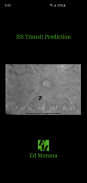
แอปพลิเคชั่นนี้สร้างการคาดการณ์การขนส่งของสถานีอวกาศนานาชาติ (ISS) สำหรับดวงอาทิตย์ ดวงจันทร์ และดาวเคราะห์
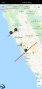
ผู้ใช้ระบุตำแหน่ง ซึ่งรวมถึงละติจูด ลองจิจูด และระดับความสูง แอปพลิเคชันดาวน์โหลดข้อมูลวงโคจรล่าสุด แอปพลิเคชันสร้างแผนที่คาดการณ์การขนส่งซึ่งมีเส้นทางการคาดการณ์สำหรับการขนส่งแต่ละครั้งภายในรัศมีการแจ้งเตือนที่ระบุ
รุ่น Pro เท่านั้น: ระบุและบันทึกสถานที่หลายแห่ง, บันทึกแผนที่การคาดการณ์หลายรายการเพื่อดูในภายหลัง, เพิ่มการขนส่งสาธารณะไปยังปฏิทิน, ดูแผนที่ด้วย Google Earth, ผู้ใช้ระบุองค์ประกอบสองบรรทัด ไม่มีโฆษณา
รุ่น Pro เท่านั้น: มีการซื้อในแอป: ปลดล็อกดาวเทียมเพิ่มเติม: คำนวณการผ่านหน้าของดาวเทียมใด ๆ รวมถึงสถานีอวกาศ Tiangong และกล้องโทรทรรศน์อวกาศฮับเบิล
หน้าจอผู้ใช้
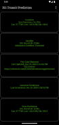
หน้าจอหลักมี 5 ปุ่ม:
•ตำแหน่ง - กดปุ่มนี้เพื่อเพิ่มหรือเลือกตำแหน่งการสร้างการทำนาย
•ดาวเทียม - กดปุ่มนี้เพื่อเปลี่ยนดาวเทียมขนส่ง (รุ่น Pro เท่านั้น ต้องซื้อในแอป)
• องค์ประกอบเส้นสองเส้น (TLE) - กดปุ่มนี้เพื่อดาวน์โหลดองค์ประกอบวงโคจร
•สร้างการคาดการณ์ - กดปุ่มนี้เพื่อเริ่มการสร้างการคาดการณ์
•ดูการทำนาย - กดปุ่มนี้เพื่อดูแผนที่การทำนายหรือไฟล์ข้อความ
เมนูตัวเลือกมีดังต่อไปนี้:
•ตำแหน่ง - กดเพื่อเพิ่ม เลือก แก้ไข หรือลบตำแหน่งที่บันทึกไว้ (เวอร์ชัน Pro เท่านั้น)
•การคาดการณ์ - กดเพื่อดู แบ่งปัน หรือลบแผนที่การคาดการณ์ที่บันทึกไว้ (เวอร์ชัน Pro เท่านั้น)
•การตั้งค่า - กดเพื่อตั้งค่ากำหนดของผู้ใช้
• ไฟล์ DEM - กดเพื่อแสดงรายการหรือลบข้อมูล Digital Elevation Model (DEM) ที่ดาวน์โหลด
•ช่วยเหลือ - กดเพื่อแสดงหน้าช่วยเหลือนี้
•เกี่ยวกับ - กดเพื่อแสดงเวอร์ชันแอปพลิเคชัน เครดิต และลิงก์
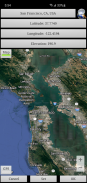
สถานที่ตั้ง
เพิ่มตำแหน่งการสังเกตที่มีชื่อโดยคลิกปุ่ม "ตำแหน่ง" ที่สามารถเข้าถึงได้จากหน้าจอหลัก
สามารถป้อนพิกัดตำแหน่งด้วยวิธีใดวิธีหนึ่งต่อไปนี้:
•ด้วยตนเอง - ป้อนละติจูด ลองจิจูด และระดับความสูงในกล่องข้อความ ค่าบวกแสดงถึงทิศเหนือและทิศตะวันออก ค่าลบแสดงถึงทิศใต้และทิศตะวันตก สามารถป้อนระดับความสูงเป็นเมตรหรือฟุตเหนือระดับน้ำทะเล ขึ้นอยู่กับการตั้งค่าหน่วยการทำนายในปัจจุบัน
•ค้นหา - กดปุ่มค้นหาเพื่อค้นหาสถานที่
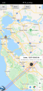
•อินพุตแผนที่ - ใช้แผนที่เพื่อซูมและเลื่อนไปยังตำแหน่ง การกดปุ่ม Set จะตั้งชื่อสถานที่ พิกัด และระดับความสูงในกล่องข้อความ ระดับความสูงของพิกัดปัจจุบันถูกดึงมาโดยใช้การตั้งค่าแหล่งข้อมูลระดับความสูงที่ระบุ สลับระหว่างโหมดแผนที่และดาวเทียมโดยสลับปุ่มแผนที่/วันเสาร์
• GPS - โดยการกดปุ่ม GPS แอปพลิเคชันจะใช้ GPS เพื่อรับพิกัดตำแหน่งและระดับความสูง
ใช้หน้าสถานที่ที่สามารถเข้าถึงได้จากเมนูตัวเลือกเพื่อแก้ไขและลบสถานที่ที่บันทึกไว้ (รุ่น Pro เท่านั้น)
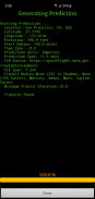
การสร้างการคาดการณ์
เมื่อป้อนตำแหน่งและดาวน์โหลด TLE แล้ว ให้กดปุ่ม "สร้างการคาดการณ์" เพื่อเริ่มสร้างการคาดการณ์ แถบความคืบหน้าจะบ่งบอกว่าต้องใช้เวลานานเท่าใดจึงจะเสร็จสิ้นกระบวนการ อาจใช้เวลาสักครู่เพื่อสร้างการคาดการณ์ ทั้งนี้ขึ้นอยู่กับความเร็วโปรเซสเซอร์ของคุณ การกดปุ่มยกเลิกจะยกเลิกการทำนาย
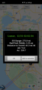
กำลังดูการคาดการณ์
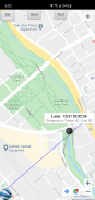
เมื่อการสร้างการทำนายเสร็จสมบูรณ์ คุณจะสามารถดูแผนที่การทำนายหรือไฟล์ข้อความได้ การกดปุ่มดูการคาดการณ์จะแสดงแผนที่การคาดการณ์ที่สร้างไว้ก่อนหน้านี้ ปุ่มข้อความภายในมุมมองแผนที่จะแสดงข้อความการทำนาย ปุ่มแผนที่/วันเสาร์จะสลับระหว่างโหมดแผนที่และโหมดดาวเทียม
ภายในมุมมองแผนที่กดปุ่ม Google Earth เพื่อดูแผนที่ใน Google Earth (รุ่น Pro เท่านั้น) กดปุ่มบันทึกเพื่อบันทึกคำทำนายเพื่อดูในภายหลัง (รุ่น Pro เท่านั้น)
ภายในหน้าต่างข้อมูลการขนส่งสาธารณะ ให้กดปุ่มเพิ่มในปฏิทินเพื่อสร้างกิจกรรมในปฏิทิน (เวอร์ชัน Pro เท่านั้น)
ใช้หน้าการคาดการณ์ที่สามารถเข้าถึงได้จากเมนูตัวเลือกเพื่อดู แบ่งปัน และลบแผนที่การคาดการณ์ที่บันทึกไว้ก่อนหน้านี้ (เวอร์ชัน Pro เท่านั้น)
สิทธิ์
ตำแหน่ง: จำเป็นเฉพาะเมื่อมีการเลือกตัวเลือก GPS ระหว่างการป้อนตำแหน่ง
ISS Transit Prediction - ข้อมูล APK
เวอร์ชั่น APK: 3.1.1แพ็คเกจ: com.ed_morana.iss_transit_prediction_freeเวอร์ชั่นล่าสุดของISS Transit Prediction
เวอร์ชั่นอื่น


 4.14
4.14


แอปในประเภทเดียวกัน

คุณอาจจะชอบ...


